Sunday morning saw my return to the triathlon scene after a couple of months off, competing in the Cronulla Olympic Distance Triathlon With all the weddings and buck’s parties after New Year’s I hadn’t done all that much training, and when I started up again a couple last month I immediately got shin splints from running too fast too soon. Still, I’d paid my entry fee so figured I might as well do the race.
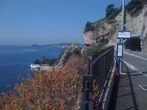
I had to head down to Cronulla on Saturday to register and drop my bike into transition, then return at the crack of dawn on Sunday morning for the actual race. Saturday evening was nice and warm, with decent size waves promising to make the swim eventful. I’d been swimming at Bondi earlier in the day having fun in the waves, and since the ones in Cronulla were breaking much cleaner all was looking good. Race start was scheduled for 0645, and my wave was scheduled for 0745.
Woke up on Sunday morning and must have been a bit dopey, as I was leisurely eating my breakfast when I realised I should have left 10 minutes previously. The transition area is closed off before the race starts, so, although I wasn’t starting until 0745, I still had to have all my stuff organised in transition before 0630. I managed to get into transition just as they announced it was now closed, so I was a bit rushed in my preparation. I set everything up and walked out of there to join the pre-race toilet queue. While standing there I realised that not only had I still got my sunnies and running cap still with me, I’d also left all my race gear (lycra shorts, top & rash vest) in transitions, meaning I’d nothing to wear for the race. Thankfully they let me in to get my gear!
I ambled down to the beach about 10 minutes before my wave start, noticing that the waves were considerably more confused than yesterday evening, but, despite not having done any swimming since the beginning of December, I wasn’t worried. Some poor guy in the wave in front of me couldn’t get past the break: race effectively over after three minutes. After a brief instructive chat from the Technical Official, the horn sounded and we were off. I got going reasonably well, ducking under the incoming waves, but there was a lot of water moving around and you could really feel the pull if you came up too soon after the wave had passed. I did it twice and got sucked back a couple of metres, but that was the worst of it.
Out to the buoys, left turn for a few hundred metres then back into shore, constantly watching for a wave to catch in. Managed to catch a beauty, body surf the last 50m and stand straight up on the beach. Due to the big waves the swim had to be shortened from the expected 1500m to closer to 1000m, and relocated further down the beach where the surf lifesavers deemed it was safer. The downside to this was we had to run about 1.5km to get back to our bikes. Not ideal for me really, but it wasn’t too bad in the end.
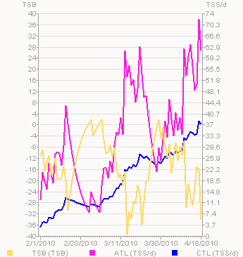
Once out on the bike I resolved to take things easy enough not to fry myself on the run, especially since I’d had shin splints up until a few days previously. It was a two loop, out and back course, and it wasn’t until I reached the turnaround that I realised I’d had the wind behind me up until then and the way home would be a tiny bit harder. Towards the end of the bike my lower back was hurting a bit, just as it had done in Canberra, reinforcing my belief that the bike shop sold me a frame one size too big, so will have to trade it in before next season. I rode into transitions feeling fine and wondering what shape my run legs would be in.
It turns out that cruising the bike worked beautifully and my legs were fine, so I just concentrated on settling into a conservative pace so as not to wreck my shins again. The course had 4 small inclines per lap, which, although not super steep, were enough to prevent me settling into a nice rhythm. I was careful not to drink too much water or electrolyte, fearing that bloated feeling with too much liquid sloshing about, but things went smoothly and I crossed the line in 2:34:10.
Spilts:
| 1.5km Swim/Run | 22:26 |
| 40km Bike | 1:21.34 |
| 10km Run | 50:10 |
In retrospect, I went way too easy on the bike, being a full eight minutes slower than the last time I did this distance (albeit on a different course), though my run was almost four minutes faster which I’m pretty happy with.
That’s it for triathlons for this season. Next race is the Sydney Morning Herald Half Marathon on May 17th.