Climbing

In the Tour, climbs are categorised according to a combination of distance and elevation gain. Cat 4 is the easiest, then there’s Cat 3, Cat 2, Cat 1 and finally HC (hors catégorie/outside category) as the hardest. An HC climb will take the pros up to an hour and they’ll ride it just under their threshold power.

Not having many mountains nearby I’ll have to mimic the effort, so I’m going to translate an HC effort to a 20min SST interval (SST = 90% of threshold). Working back from there, I’ll do 15min SST for a Cat 1 climb, 10min SST for a Cat 2 and 5min SST for a Cat 3. I’m not going to bother with Cat 4s.

I’m also not going to bother trying to space the climbs according to how they appear in a stage. I’ll do them in the right order, but will take a standard 5min Z1 between each climb, and, if I haven’t completed the required distance for a stage, I’ll finish the remainder at Z2.

Third de France - Stage 5

Pros: Lorient to Quimper, 204.5km, Sprint Stage

Me: 68km Z2, Sprint finish

Crap day today. Had a splitting headache all day and just couldn’t shake it, so no ride today.

Third de France - Stage 4

Pros: La Baule to Sarzeau, 195km, Sprint stage

Me: 65km Z2, sprint finish

Another comfortable day. Supposed to do 65km but ended up with almost 70km, and unlike the pros, I got rained on for the last 45km. Normally wouldn’t have bothered riding in crap weather, so what I’m now calling the Third de France is providing useful motivation.

TDF - Stage 3

Pros: Cholet to Cholet, 35.5km, Team Time Trial

Me: 4 x (1m Z5, 2m Low Z4)

When riding a Team Time Trial you end up riding above FTP (aka threshold) for a short time when you’re the guy on the front, and a bit longer under threshold when you’re drafting behind a team mate. The pros took about 38mins, so a third of that is 12-13 minutes for me. I’ll do a minute over threshold, followed by two minutes under and repeat 4 times for a total of 12mins.

Training Zones

Time for a quick detour into training zones. I have a power meter on my bike, which is a device which measures how much work I am doing at any given moment. Using a power meter, your training zones are defined in terms of your Functional Threshold Power. FTP, as it’s known, is just the maximum average power you can sustain for approximately 1 hour, measured in watts (W). In my case, right now my FTP is approx. 285W.

Given that, the zones are defined as follows:

</table>
ZoneName% FTP
1Active Recovery0-55
2Endurance56-75
3Tempo76-90
4Threshold91-105
5VO2Max106-120
6Anaerobic120+
TDF - Stage 2

Pros: Mouilleron-Saint-Germain to La Roche-Sur-Yon, 182.5km, Sprint Stage

Me: 61km Z2, 10 sec sprint to finish

Easy enough to start. While this is a comfortable pace, the fact is the training effect will come with the volume over the first week, then more intense work over the following two weeks as the pros get into the mountains. At this stage it’s just a case of do the distance and stick to the comfortable pace.

Cramming

Well it’s been a really lazy two months as we moved to Brisbane, dropping from a consistent 5 rides per week to one or none. That descending blue line if my fitness decreasing over the last couple of months. It’s Winter, so not a big deal, were it not for the fact that I’m off to Europe in a bit over a month with some solid rides scheduled in the mountains, including a weekend riding with two club mates who are way better cyclists than I am.

So, time for a training cram session and I’ve decided to try to ride a mini Tour de France. The Tour started yesterday, so my basic plan is to ride one third of the distance of each day’s stage while aiming to make my sessions approximate the day’s stage. I’ll figure it out as I go along, but I should end up with a solid three weeks of training and some appreciation for what the pros go through.

I’ve missed the start of the Tour as we were away for the weekend, so I’ll be riding a day late. It’s Sunday evening now and the pros will shortly be riding Stage 2. I’ll start with Stage 2 tomorrow.

Colle Fauniera

Where to start with Colle Fauniera? Well, it’s relatively unknown and I’ve seen it referred to as the “hardest climb you’ve never heard of” or something along those lines. It featured in a coffee table book which provided a lot of inspiration for this trip, Daniel Freibe’s “Mountain High”. The blurb sounded good and it was in the right area to fit into the road trip, so I put it on the list.

Having done the hard part of Ventoux, I really wasn’t looking forward to this after all. Part of me was as it’s quite a picturesque climb and it was the first high climb info the tip, topping out at 2511m. However, the bit in the middle note of 10% gradient wasn’t doing to be fun at all. At my weight and power, once the gradient hits 10% it’s proper hard work, even with easy gears.

My original plan had been to ride up and over the top, then back down the valley on the other side, however that ‘valley on the other side’ was the one I drove in on the day before and it’s a heavily-trafficked route over from France with plenty of trucks, so I decided to skip that idea. With an early checkout the next day, I opted to drive to Pradlèves and just ride the climb. Wise decision.

The early morning start had me on the bike at 7:40 and the valley road was quiet and still. The first part of the climb is not that hard and it meanders through a nice gorge, reminiscent of Col de la Cayolle near Barcelonette. The gradient is nice, the stream is burbling and all is right with the world.

However, the fun has to end some time and there’s always some hard work to be done on these climbs. The beautiful views have to be earned. The gradient starts rising and at every turn there’s a little sign telling you what the gradient is. I was getting confused as I assumed that, like France, they were telling you what the average gradient for the next kilometre was, and quite frankly they were starting to scare me with gradients like 14% and 15%. I finally figured out it was only the gradient of the corner in question.

Once I got to the village of Campomolino the really hard part started. Minimum 9% for the following 6.5km with regular stretches over 10% and a final kilo to the Santuario San Magno over 11%. By this time I was starting to appreciate the alternative name for the climb, Colle dei Morti, the Pass of the Dead, and the regular shrines featured along the route. My legs were certainly dead by this stage.

After the Santuario the gradient backed off and the road narrowed significantly. It seems that part of the Italian Army’s Alpine troops are stationed around there, so that’s the last “civilised” place that warrants a proper road. The remainder was old, narrow and a bit sketchier with gravel and mini rockfalls in places.

I was now past the tree line riding along a cliff-side track and heading towards a more exposed Alpine meadow. I could see a car parked up ahead which seemed a bit odd as it was the middle of nowhere. However, as I got closer the reason was revealed - no more road. Clearly the Fauniera isn’t an important pass, so no-one clears the road and from here on up the snow hadn’t really melted.

I hiked around the first blockage, rode a bit, hiked around another, rode a bit, rode around a final blockage before deciding to call it a day. I could see three more blockages in the next 600m, two of which you couldn’t walk around as they went right up to the edge of the slope and I didn’t really fancy hiking through snow in cycling shoes. Plus, with another 500 vertical meters to climb the snow was almost certain to get worse.

Still, the view from where I turned around was pretty good. The descent wasn’t that great, given that the first section was a goat track with a loose surface, and the second part was bloody steep with sheer drop offs so I’d no intention of letting the bike run. Down at the bottom there was jus time to throw the bike in the car and get back to the B&B for a shower before checkout time. Onwards to Susa!

Mont Ventoux

Mont Ventoux, also known as le Géant du Provence, the Giant of Provence, is one of the most famous Tour de France climbs and has been on my to-do list for a while. Given that May is still quite early for some mountain passes to be open, detouring to France to ride Ventoux made perfect sense as it’s both far enough South and low enough to be clear at this time of year.

There are three ways to the top; two hard ones and an easier one, with the one starting in Bédoin the hardest and ‘official’ Ventoux climb. If you’re only going to ride one side, then the Bédoin side is the one to do. However, there’s a club called les Cinglés du Mont Ventoux, loosely translated as The Mont Ventoux Nutters, to which you gain access by riding all three sides in one day. I figured I’d give it a go, so I sent off my €20 and they sent me a brevet card which needed to be stamped at the bottom and top of each climb.

The recommended route is to start in Bédoin to get the hardest climb out of the way first (21.5km @ 7.6%), then descend to Malucène to climb from there (21km @ 7.3%), leaving the easiest climb from Sault until last (24km @ 5.1%). So, with a hearty breakfast sitting in my belly, I descended the 4km back into Bédoin, got my card stamped, turned around and got the day started.

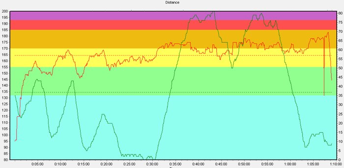
The first few kilometres are comfortable enough and there’s ample time to admire the scenery, but once you get to the St. Estève bend the gloves are off and you have to knuckle down to some hard work. The next 10km to Chalet Reynard averages 9% and there’s nothing you can do except grind it out. Even with the easiest ‘normal’ gears you can get on a road bike, 34x32, it still took me an hour to ride that section at an average heart rate of 161 (max. is 190).

The gradient never lets up, so there’s no easy sections to get your breath back. However, there’s plenty of graffiti left over from the various times that the Tour de France has passed this way, including one of Marco Pantani, who last rode Ventoux in 2000. I suspect it was painted in recent years rather than lasting from 2000 though! Shortly before Chalet Reynard there’s also a small hut with various items dedicated to early car races on Mont Ventoux - it was famous before cycling too!

The weather station at the top of the mountain is the beacon letting you know exactly how far you still have to go. The hard part is through the forested lower slopes so you rarely see the top, but, as you approach Chalet Reynard, the trees start to open up and you can start seeing the progress you’ve made.

I took a breather at Chalet Reynard and refilled my water bottle before continuing on. The gradient eases back a bit from here to the top to ‘only’ 8%, but it was partially replaced by a bit of wind. Mont Ventoux is known for some ridiculous winds, with last year’s stage of the Tour needing to be shortened as there were 100km/h+ winds blasting across the exposed top. It wasn’t that bad for me though and after some more plodding I finally made the top. Success!

The downside to reaching the top was seeing that there was a barrier across the descent to Malucène, with a digger and various trucks working nearby. I approached one of the workers to see if the road was closed and he said yes. I asked “even for bicycles” as often workers are quite happy to let bikes through, but today it was not to be. Road closed for everyone.

That was a bit of a pain in the arse as it meant the attempt at three-in-one-day was over and done before it got going. I got my card stamped at the top anyway and figured I may as well do the Sault climb too. The top section of the descent wasn’t as much fun as I’d anticipated. I find I usually take a day or two on these trips to get my eye in and get comfortable reading turns so I was a bit cautious as this was my first proper descent and the sudden wind gusts made things a bit unpredictable. After Chalet Reynard I was back in the shelter of the trees, and, apart from a relatively flat bit at the top, I could concentrate on my line for the remaining 15km.

I stopped for a coffee in Sault, sitting out on the terrace of a bar from which I could see the top of Ventoux in the distance. A bit daunting seeing it so far away and realising I’ve got it all to do again. Leaving Sault, there’s a brief descent, followed by a brief bit of harder climbing before the road settles down to its easier gradient and I could look around at the rolling countryside dotted with lavender farms. It’s quite picturesque. The road meanders around various outcrops at a reasonably steady gradient, never gaining massive amounts of vertical but also never slack enough that you get up a decent amount of speed.

By this stage I was getting a bit over it. It wasn’t that it was too physically demanding, more that my heart wasn’t really in it now that the main goal was scuppered. Once the climb from Sault reaches Chalet Reynard it’s the same route to the top from there as I’d already ridden from Bédoin, so I decided I wouldn’t bother with that again and would descend straight from Chalet Reynard. Shortly after making this decision the gradient eased and it was at last possible to keep the pace up all the way to CR.

I had a quick Coke in the sun and then switched on the GoPro for the fun descent back to the B&B. At 9% nearly the whole way it promised to be reasonably quick, even if I didn’t know the route so would have to be a bit cautious into the bends. The top half was great fun, but then I started catching a VW and ended up stuck behind him for the second half. The popularity of the climb meant that there was a steady stream of cyclists coming up the other way, plus fairly regular cars, so I wasn’t comfortable trying to go around him. Thankfully he seemed up for it and kept up a reasonably quick pace so it wasn’t ridiculously slow. 1h10 to climb up, just under 12mins to get back down. Good fun!

The Lead Up

So, before all the cycling starts, I figure I should lay the groundwork for what follows. My plan was to ride 1000km per month in the lead up to departure and lose as much weight as possible. The former was reasonably successful, the latter less so.

Above is the record of my training since Jan 1st, expressed in weekly TSS (Training Stress Score - blue bars) and overall fitness level (red line). Simplistically, increasing the weekly TSS will lead to increasing levels of fitness.

January got off to a good start with a very big week down at the Tour Down Under and then decent amounts of work into February. The end of Feb. and beginning of March were a bit of a wash-out in Sydney which hampered things somewhat, but once that was dealt with I managed to get some solid work done through until mid-April, where my CTL peaked around 82. The last two weeks before jumping on the plane say me getting last-minute things organised and as much work stuff out of the way as possible which saw the training take a bit of a hit, but if I’m honest I was quite tired after a series of solid back-to-back weeks.

Summary:
Jan: 1054km
Feb: 895km
Mar: 826km
Apr: 1317km

Net result is that I got on the plane with about 4400km in my legs since Jan 1st which is the most I’ve ever done by this stage in the year. My CTL of 76 is also quite a bit more than I’ve ever gone to Europe with before.

As for weight, well that dropped form 89.5 in Jan to 85kg in May. Not too bad, but I probably doll have lost another few kg if I’d actually been careful about what I ate. Almost all of that weight loss is simply from doing more cycling.

Anyway, I’m here now and we’ll see what happens.